Backpacking
Shawnee State Forest -- Southern Ohio
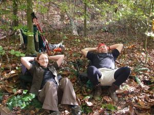
Shawnee Trail: 10/25 - 10/26/08
The Shawnee State Forest derives it's name from the Shawnee Indiands that once inhabited the land. This park that began in 1922 is sometimes called "The Little Smokies".
We'd soon find out why.
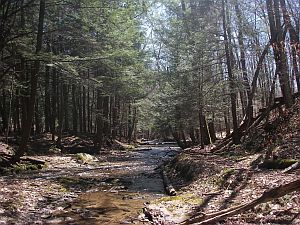
The Shawnee backpacking trail is one of only a few true backpacking trails in Ohio. There are 7 designated camping areas that cover approximately 60 miles. Besides hiking there are other area attractions. There is the Serpent Mound, Tremper Mound, and more.
A good group of people went on this excursion. It was a nice weekend, albeit hilly.
Day 1 and 2 Photos
Pennyslvania's Grand Canyon -- Ansonia, PA
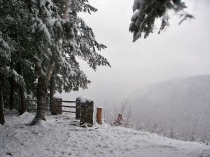
West Rim Trail: 11/17 - 11/18/07
The West Rim Trail for the most part runs along the western rim of the Pennsylvania Grand Canyon, from which it derives its name.
This trail has had the honor of being chosen one of the best trails in Pennsylvania by Outside magazine. Excerpt from fallipa.com
I left directly after work on a Friday to meet up with a couple people for the drive down to the trailhead. We hiked in a short distance then set up our 3-man tent for the night.
Saturday morning we met the rest of the group and hiked our way to camp about 7 miles in. The trail was pretty easy and the miles went by fast.
We set up our tents by a stream with a lot of flat land for tents and set about gathering firewood. It took a little bit to get the fire going due to the wetness of the wood, but it was well worth the effort! We sure needed that fire on this cold day. It was about 35 degrees, with a 28 degree low.
We awoke on Sunday to at about 2 inches of white snow on the previously leafy ground. I've never backpacking while it was snowing and found it quite pretty. You didn't notice the cold so long as you kept moving.
We did a section of this 30 mile linear trail...leaving one car ahead of us at our ending point. View the Photos.
Day 1 Photos
Day 2 Photos
Allegheny National Park, PA
Tanbark Trail: 7/7 - 7/8/07
The Tanbark Trail is a linear trail in the Hearts Content Scenic area in the Allegheny National Park, PA. Five of us ventured out to this secluded trail last weekend, 7/7/07.
On a good note, the trail was pretty easy, however we spent much of the time back at camp swatting away nats.
Mosquitos seem to have an unnatural love for my skin over anyone elses. On Monday I took a good look at my arms and legs and to my horror I realized the mosquitos had a feeding frenzy.
Day 1 Photos
Day 2 Photos
Allegheny National Park, PA
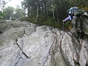
Minister Creek Hiking Trail: 5/5 - 5/6/07
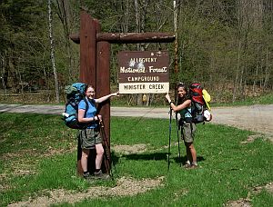
The Minister Creek Hiking Trail is a popular one night loop. Cliffs, outcrops and massive boulders are prevalent along much of the trail. The trail is well blazed with a metal white diamond being the marker.
The hike on day one was enjoyable although when we stopped for a break the tiny little bugs were flying around, bothering us a bit. We got to the camping area with no problems and eventually found a nice camping spot alongside a stream.
At night we enjoyed a campfire and conversation with our neighbors a short distance away. We welcomed the warmth of the fire as it had gotten quite chilly out.
On Sunday morning we took our time getting out of our sleeping bags. I laid in my bag listening to the rather loud noise of the stream next to the tents. Eventually we got up and made breakfast as we packed. I was feeling a big 'off' from the all the Cinco de Mayo revelry the night before. We took a short hike upstream to check out the cascades then backtracked back to camp to collect our backpacks.
There seemed to be a lot more steeper uphills on this day. Eventually after more uphills and little stream crossings we arrived at the Minister Creek Vista, which was a nice spot for a break. That view would be quite pretty in autumn.
From the overlook we managed to follow a wrong loop which was identically blazed. Eventually we made our way back and continued on the correct loop, following it back to our car.
Day 1 Photos
Day 2 Photos
Allegheny National Park, PA
Morrison Hiking Trail: 4/21-4/22/07
The Morrison Hiking Trail is a small, popular loop that's idea for a quick one-night trip. The trail offers fine scenery and nice camping.
The MT is one of the most scenic and popular trails in the Allegheny National Forest. Some of the highlights are rock outcrops and massive boulders, scenic mountain streams with cascades, Allegheny Reservoir, and beautiful campsites.
I arrived at the Morrison trailhead around noon on a sunny Saturday . The drive there was about 4 hours. The air was crisp and the hike was enjoyable and pretty easy. The trail to the campground parallels the creek much of the way. I only encountered a couple day hikers along the way. The campground was great. 95% of the sites were empty so I had my pick. I chose a cool site on the water, far away from the other campers.
On Sunday the first couple miles were a couple hundred feet up from the lake. Then it was onto an old fire road for a bit then into denser woods where I followed another long creek. There was definately more elevation changes on day 2. I saw no one in those 5.5 miles until I arrived back at my jeep where I was greeted with a trail angel.
Back in the parking lot I was changing out of my boots when a woman walked up to me, "Do you want some cupcakes?!" "Sure!" "You'd be helping us out..it's my husbands birthday.." "I'm all for helping people!!"
After a snack of cupcakes I drove the few minutes down the road to the Rimrock Overlook. They really spent a lot of money constructing the stone overlook. And they created this winding staircase, not much wider than shoulder width, with about 30 steps into the rock with a metal hand railing which takes you down to the woods and hiking trails. I was really impressed. I had never seen such a thing.
Day 1 Photos
Day 2 Photos
Rimrock Overlook Photos
Monongahela National Forest, WV
Dolly Sods Wilderness: 11/25 - 11/26/06
A bit of history:
The Monongahela National Forest features over 800 miles of hiking trails, Seneca Rocks climing area, and Spruce Knob is the highest point in the state.
The first trails were made by Indians who camped along the valleys and major rivers. Later, more permanent communities were formed which was the genesis of tribes such as the Seneca.
Settlers began settling into this fertile land. The Civil War was fought on what later became national forest land, to control passes through the rugged mountains.
As time went on and the need for wood increased, logging found it's way to the mountains of West Virginia. In just 30 years much of the forests were obliterated which not only devastated the mountains, but the lowlands which became flooded from lack of vegetation to absorb the flow of water from the mountains.
In 1907 the Monongahela National Forest was created to repair the land and bring it back to its former glory. The forest began to recover and deer, black bears, and small critters returned.
The Monongahela is now one of West Virginia's special natural resources.
West Virginia's Monongahela is a fantastic getaway for hikers and weekend backpackers. The forest is an impressive 900,000 acres; 800 miles of which contain hiking trails.
After a day of climbing at Seneca Rocks and getting a good night's rest at Yokums Motel, my brother and I drove the short distance to Dolly Sods for an overnight backpacking trip.
The hike back to the campsites were laden with rhododendron and pine trees. The scent of pine as we hiked was sweet. There were a couple spots along the trail that were pretty muddy, but nothing we couldn't handle.
During World War II, Dolly Sods was a bombing range, and although we didn't see any, there are still shells lying around.
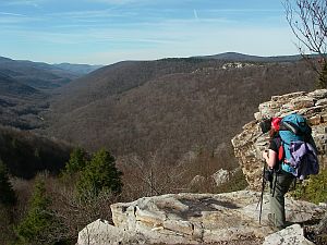
Our camping spot for the night had an awesome view of Red Creek Canyon, which is featured in the photo on the left.
This trail, across the street from the Dolly Sods Picnic Area, is a 19 mile loop. We hiked the beginning part of the trail in an in and out fashion which mad for a perfect overnighter.
Day 1 Photos
Day 2 Photos
Seneca Rocks Scenic Overlook, Champe Rocks, Seneca Rock
The Long Trail, VT
Killington to Jonesville...85 miles: 10/6 - 10/17/05
The Long Trail is called Vermon's "footpath in the wilderness" and the oldest long distance hiking trail in America.
I backpacked roughly 85 miles of the 270-mile oldest long distance hiking trail in America. To my chagrin, I seemed to have chosen the section with some of the toughest terrain.
It was a challenging experience; both mentally and physically.
Some of my favorite moments seemed to be of the people I met along the trail. Towards the end of the trip my knee and ankle joints were screaming in protest as I climbed up and down the final steep mountains. Knowing that I pushed myself, I gained a true sense of accomplishment having finished the mileage I set out to.
Follow this link to my daily journal entries and photos on trail journals . com.